It has been used to identify suspected weapons sites, monitor troop movements, and chronicle war damage and allegations of genocide. Now, however, satellite imagery is being used to tackle one of the developing world’s most persistent problems – the scourge of modern slavery.
An innovative programme involving space imaging and anti-slavery experts at the University of Nottingham has established the prevalence of sites in industries associated with slavery, including Asian brick kilns and fishing camps, in an approach they suggest may be applicable to other forms of compelled labour.
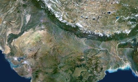
In the widest application of the idea so far, the team has used commercial satellite imagery to build up the first proper estimate of the number of people working as bonded labourers in the area that runs across the clay fields of Asia through Pakistan, India and Nepal, known as the “brick belt”.
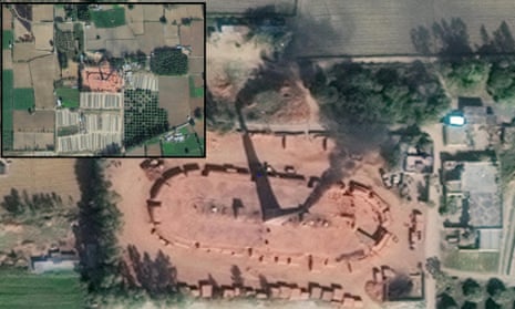
The oval brick kilns – easily identifiable from space – often employ dozens of people, including whole families, lured with the promise of work and an advance on their salaries.
Once at the hazardous and highly polluted camps, however, they find they are little more than unpaid slaves, prevented from leaving and subjected to rape, violence and threats.
The project is the brainchild of Dr Kevin Bales, an anti-slavery researcher who has long nurtured the hope of using satellites to track modern slavery and nudge governments into action with the evidence gleaned.
Bales, one of the first researchers to attempt to quantify the number of people caught up in modern slavery, already knew from examining satellite pictures that different kinds of slavery were identifiable at sites including kilns, strip mines and quarries.
“The brick kilns in Pakistan I looked at, and sites like charcoal camps in Brazil, are so big – and had such unique patterns – that I realised you could see them from space,” said Bales.
“I had spoken to Google but it had always been a question of money. When I moved to Nottingham two years ago, they said: ‘You now have a geospatial institute with people who have worked for the UK space agency.’
“We know the proportion of people – what we don’t know is the exact number and all of the locations.”
Describing the practice of modern slavery in brick kilns, which he has researched first-hand, Bales said: “It is normally done through an offer of work. Individual migrants and migrant families are told they can live and work, and that food will be provided and they will be given a bit of an advance.
“But then, once on site, they find there a couple of thugs who have complete physical control, and kids are to work in the kilns. Rape of women and girls is common.”
The brick kilns project is a development of Bales’ earlier efforts to use imaging to identify fishing camps in the Sundarbans of Bangladesh, where child slavery is common.
“With the fishing camps, suddenly we were able to say to the authorities, ‘Here are five more camps to say that you have no record of.’”

Photograph: Planet Observer/Universal Images Group/Getty Images
Doreen Boyd, one of the imaging experts involved, said: “[The brick kilns project] was proof of concept. It was relatively easy because they are so distinct. Next we want to develop the idea to map other activities using slavery, including mining and charcoal camps.
“So far, we have been dictating where – for instance – the brick belt is. The next step is to flip the thinking and ask the machine to tell us exactly where the brick belt is.”
Bales is more ambitious still, asking whether technologies like spectroscopic analysis of satellite images might be able to detect where informal gold mines are in countries like Ghana, by tracking the contamination of rivers with the mercury they use.
Jakub Sobik of Anti-Slavery International described the tracking of industries associated with modern slavery from space as particularly useful in identifying unknown camps in places where governments were more willing to work against issues like child slavery and forced labour.
Sobik said: “Slavery happens in different contexts, with governments and systems that are more and less willing to counter the problem. You could see this being useful in a place, say, like Brazil, that has much more of a political will to target child and forced labour.”

Comments (…)
Sign in or create your Guardian account to join the discussion